Stage 1: Florence to Pontassieve

Florence to Pontassieve

Your adventure begins! Get the official starting stamp at Basilica Santa Croce in Florence. Then follow the tranquil Arno River east. This first stage carries Pilgrims from Florence’s tourist bustle into the gradually increasing spaciousness of the Via di Francesco.

Enjoy soft, riverside gravel paths, then hilly olive groves. The stage completes in Pontassieve. Book in advance, as accommodations can be limited.

View of Basilica of Santa Croce with Arno river in the background. Santa Croce is the official starting point of the Via di Francesco in Florence.

Florence

Stage 2: Pontassieve to Consuma

GPX Maps

We strongly recommend pilgrims use offline GPX to navigate the trails.

Quick Glance

Start:
Firenze (Florence), Basilica of Santa Croce
Finish:
Pontassieve, Piazza Vittorio Emanuele II
Distance:
18.9 km 
(11.7 mi)
Travel Time:
6 hours
Total Ascent:
495 meters
Total Descent:
450 meters
Trail Surface:
Concrete sidewalk, gravel trail, some concrete road
Trail Signs:
Sparse. No clear starting sign in Florence. Red/White painted tags appear outside city limits on utility poles. Use GPS app.
Water Sources:
Water fountains on Arno River trail at Florence city limits. Water for purchase in Compiobbi cafe.
Food:
Pastry shop at half-way mark in Compiobbi (9.3 km).
Navigation Notes:
No trail signage inside Firenze.
Services at Stage Destination:
Laundry, Farmacia, Restaurants, Market, Bank
Quick Links

Preparation

Stamps from Santa Croce
Get your first stamp at Basilica di Santa Croce

It’s your first day on the Via di Francesco! Start early to minimize sun and heat exposure. Consider booking your accommodations the day before, as space is limited in Pontassieve.

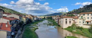
Pilgrims will walk through the towns of Florence (Firenze), San Jacopo al Girone, Compiobbi, Ellera, Le Falle, Sieci, and arrive in Pontassieve.
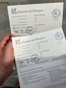
Stamps

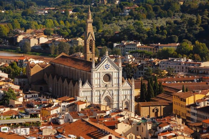
We recommend to get your official stamp (also known as “timbro”) at Basilica Santa Croce the day before you start. Ask for a stamp at the entrance. A Friar will stamp your official credentials, and you’ll get a chance to visit private rooms just for pilgrims. If the friar is not available, go to the church bookshop inside (operating hours 9:30 am – 5:30 pm).

Note: Santa Croce has an admission fee. Check out the opening times, holiday closures, and admission fees on the Santa Croce website here.
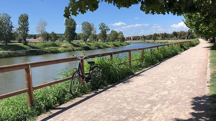
Stage 1 Highlights

Arno River on Stage 1: Florence to Pontassieve
Stroll along the lazy Arno river in the first half of the walk. Beautiful scenery. If walk in summer, consider bringing an umbrella to give yourself some shade.

Difficulty

Considered the easiest of the first six stages. Stroll along the lazy Arno river in the first half. Steep climbs take pilgrims up into hilly olive groves in the second half. Stay alert during a few busy road crossings.

Microclimate

Expect heat and little shade. The Tuscan sun can be relentless. Leave early to minimize heat exposure on hilly climbs in second half of stage. You may consider a sun umbrella for this stage, but it will be become extra baggage starting in stage 2. Hat and sunglasses are encouraged.

Navigation

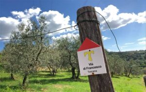
There are no signs or arrows inside of Florence. So just head toward the river. Pilgrims will spot the first wooden sign post marking the Via di Francesco around olive groves just before Compiobbi. Be sure to check your GPS apps to stay on course.

Step-By-Step Instructions & Itinerary

Wooden sign of Via di Francesco in Toscana

Step-By-Step: Stage 1

Strong Recommendation: Use the official GPX files in addition to these instructions to not miss any turns. As signs are sparse, it can be easy to miss one.

Pasticceria Andrea in Compiobbi offers a wide variety of food.
Pasticceria Andrea in Compiobbi is a great place to rest for Day 1. It offers both pastries and sandwiches.
  1. Obtain the stamp for your credential at the church bookshop in Santa Croce. Santa Croce does not open before 9:30am. Pilgrims who want an early start should consider getting the credentials the day before beginning.
  2. Leave the Basilica of Santa Croce and follow the Arno River for 6.5 km until you reach the end of the Girone cycle path. Then, follow Via del Girone until you reach Piazza Pertini.
  3. Cross Via Aretina and follow Via San Jacopo. At the end of Via San Jacopo, turn left into the countryside along Via dei Bassi.
  4. Go up the hill and then down to Compiobbi. You’ve reached the half-way point of Stage 1. It’s a very good place to get some snacks and use the toilet at the cafe in town, as there won’t be any other services until Pontassieve. Then, pass under the overpass on the provincial road, and follow the path behind the newsstand along the Arno River.
  5. Continue along the path along the river until you reach Ellera and then until you reach Le Falle.
  6. After the roundabout, turn left onto Via delle Falle and cross the railway underpass again, following a footbridge on the right. Follow the path and turn left. At the end, take Via Gricigliano and at the junction, after 300 meters, follow Via del Paretaio.
  7. Continue straight until you cross the railway again and arrive on Via Aretina. After 200 meters, you will be in loc. Sieci (12.8 km traveled).
  8. Continue on Via Aretina and after the bridge, follow the pedestrian path that runs alongside the Arno River until you meet Via Toscanini on the left.
  9. From here, head towards the roundabout on the provincial road, crossing it and following the exit for Via dei Mandorli/Via dello Stracchino. Immediately turn right and follow the farm road until you reach the locality of Massariccia.
  10. Follow the Via di Francesco signposts until you return to Via Aretina and arrive in Pontassieve.

Alternative Route

Compiobbi to Diacceto

If there’s no rooms available Pontassieve, consider ending early in Compiobbi. Then make Day 2’s destination Diacceto – about 2 hours past Pontassieve. There you’ll find the welcoming Locanda Tinti. This brings you to Consuma on Day 3, instead of Day 2.

Florence to Diacceto

It’s possible to walk to Diacceto on Day 1, but you’ll need to leave Florence very early. This would take 8-9 hours. Plus, it can be a slog if your pack is too heavy. If you have lodging in Diacceto for Day 1, be sure to communicate your expected arrival time to your lodging throughout the day. It’s possible to take a bus from Pontassieve to Diacceto.

About Pontassieve

Modern town known for its strategic bridge across the Sieve River, artisanal leather, Chianti wine, olive oil, handmade glass, and pottery.

Stage 1 in Pontassieve, photo by Simone
View from the bridge across the Sieve River in Pontassieve, photo by Simone

What’s Next: Stage 2

You’re headed to Consuma, the gateway of the Apennine Mountains and cooler temps on the Via di Francesco.

Stage 2: Pontassieve to Consuma

Accommodations

Stage 1 Accommodations for Pilgrims

Open rooms can be limited in Pontassieve, so call ahead and book early. If there are no rooms available, it’s possible to cut Stage 1 short, and find lodging in Compiobbi – about 3 hours short of Pontassieve. If you stop overnight in Compiobbi, consider ending Day 2 in Diacceto – about 2 hours past Pontassieve. There you’ll find the welcoming Locanda Tinti.

Agriturismos appear throughout Stage 1 hillsides, and may offer lodging alternatives. They tend to be pricier options.

Pilgrim Ospitale Member / Pilgrims' Discount
Breakfast Included
Dinner Available
Good for Groups
Firenze, 
18.94 km from the end of stage
€40
Firenze, 
18.94 km from the end of stage
€55-€180
Firenze, 
18.94 km from the end of stage
€17
Compiobbi, 
9.34 km from the end of stage
€60-€90
Pontassieve, 
0 km from the end of stage
€90-€130
Pontassieve, 
0 km from the end of stage
€50-€70
Pontassieve, 
0 km from the end of stage
€60-€100
Pontassieve, 
0 km from the end of stage
€50-€70

Other Stages

Distance: 18.6 km
Travel Time: 6 hours
Elevation: 1138 meters
Trail Surface: Two-thirds concrete road, then woodsy trails
Distance: 18 km
Travel Time: 6 hours
Elevation: 462 meters
Trail Surface: Forest trail, loose big rocks on descending path. Need poles.
Distance: 17.5 km
Travel Time: 6 hours
Elevation: 910 meters
Trail Surface: Forest trail, Casentinesi Forest, Uphill
Distance: 8.3 km
Travel Time: 3.5 hours
Elevation: 515 meters
Trail Surface: Forest trail, fern forest, Casentinesi National Park
Distance: 17.8 km
Travel Time: 8 hours
Elevation: 1182 meters
Trail Surface: Rocky mountain, forest trail, Sacred Forest

Printable Wakling Guide

Get printable Walking Guide for Stages 1-6 as a part of the Pilgrim Essentials Kit.

Enter your email to receive the free kit, including Walking Guide, Accommodations Guide, pilgrim Quick Start email series, and more.