Menu
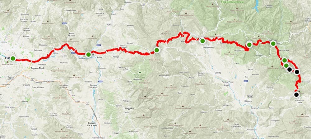
From the official starting point in Florence, the path leads you through Tuscan vineyards, into the enchanting Casentinesi Forest National Park, and to the Sanctuary of La Verna. Each stage offers a new adventure and a deeper connection to your self and nature.
The 101 km section crosses Firenze, Pontassieve, Consuma, Stia, Camaldoli, Badia Prataglia, and Santuario della Verna.

Tuscany Highlights
You’ve arrived at the Jewel of the Renaissance. Grab some food and get some rest.
This is your day to sightsee, eat gelato, and get your initiation stamp at Santa Croce. Once you get your stamp, you’ll be invited to visit special sections inside just for pilgrims. You’ll want to get your stamp today so you can start your journey early tomorrow morning.
Walk along the lazy Arno river, through hilly olive groves, and into the town of Pontassieve. Today’s track gives pilgrims their first taste of Tuscany’s up and down trails. See Stage 1.
Climb the trail early today so you can stop in Diacceto for a coffee and pastry at the famous Locanda Tinti. Then trek through a rugged forest trail to the mountain town of Consuma. See Stage 2.
Pilgrims walk downhill to the medieval town of Stia. Use hiking poles to make the descent easier. Pilgrims will be delighted by the food and sleeping options in Stia. It’s a good idea to pick up some supplies at the grocery store here. See Stage 3.
The path leads pilgrims into the Casentinesi Forests National Park, bringing a tranquil and mystical energy to the journey. Today also presents the first big route decision: Walk to the Monastery of Camaldoli, take an alternative route to the remote mountain hermitage, or stop early at Rifugio Asqua in the middle of the stage. See Stage 4.
Whether you slept at the hermitage, monastery, or Rifugio Asqua, today’s destination is a relatively relaxing hike. Think of today as an “active” rest day. Most pilgrims will arrive in Badia Prataglia around lunch time, giving plenty of time to recover from the previous hikes. See Stage 5.
Hike back up into the mountains to the remote mountain farmstay Rifugio Casa Santicchio. Pilgrims will enjoy the outdoor spa, wonderful meals, and the peaceful environment. See Stage 6.
Start early and take your time as you walk through the enchanting forests surrounding the Monastery of La Verna. St Francis was known to hike these woods and meditate and pray amongst its caves and boulders. Arrive at the monastery before 15:00 to participate in the daily procession. See Stage 6.

GPX map files help pilgrims stay on the official route, explore side trips and interesting sites, and locate accommodations.
We strongly recommend pilgrims use offline GPX to navigate the trails.
Get Around
FAQs
The Via di Francesco is divided into four sections. Each is managed by an independent regional organization. On this website you’ll find information about Tuscan stages. See information about the other stages here.
Some pilgrims prefer to start at La Verna instead of Florence because of time constraints. See our full guide here.
GPX files are digital maps that can be used by GPS apps to navigate the trail. We strongly recommend using official GPX files or GPX files from a recently updated guidebook, as signage is sometimes sparse along the trail. See our GPX page for instructions to use the map files.
Tuscan stages offer unique experiences not found anywhere else on the Via di Francesco. Stays at monastery foresterias of Camaldoli and La Verna, remote mountain rifugios, and charming b&bs give pilgrims unforgettable days and nights. See accommodations for stages 1-6.
The first six stages can challenge pilgrims because of steep and rugged mountain trails. However the effort is more than worth it. Recommendation: Take it slow.
The Via di Francesco starts with the stamp at Santa Croce in Florence. Get your stamp the day before you start your hike. See the full guide from Florence.
The Via di Francesco officially starts in Florence. It is possible to start at other stages. Popular alternative starting points include La Verna and Rome.
Yes. The cycling route is different from the walking stages. See our cycling guide.
The Via di Francesco starts in Florence and ends at St Peter’s Basilica. The trail’s four main sections cross central Italy through Tuscany and La Verna, Umbria and Assisi, Rieti, and Rome.
This website focuses on the Tuscany stages. To see other stages, see our guide with links to the other websites.
By entering your email, you get the Quick Start emails, free Pilgrim Essentials Kit, and more resources, and agree to our Terms & Conditions and Privacy Policy.

An opportunity for pilgrims, seekers, and adventurers to take an inward journey alongside the spirit of St Francis.

A Toscana, non-religious non-profit to share the discovery and preservation of Franciscan tradition, Nature, and Art.
Disclosure: We may receive affiliate compensation for some of the links on this site if you decide to purchase linked items, helping us to maintain our trails and provide services to our community of pilgrims. Read our affiliate disclosure in our privacy policy.
By entering your email, you get the Quick Start emails, free Pilgrim Essentials Kit, and more resources, and agree to our Terms & Conditions and Privacy Policy.

An opportunity for pilgrims, seekers, and adventurers to take an inward journey alongside the spirit of St Francis.

A Toscana, non-religious non-profit to share the discovery and preservation of Franciscan tradition, Nature, and Art.
Disclosure: We may receive affiliate compensation for some of the links on this site if you decide to purchase linked items, helping us to maintain our trails and provide services to our community of pilgrims. Read our affiliate disclosure in our privacy policy.